![](/images/other/stat-length.png)
![Excursión Senderismo Les Déserts - Cascade de la doriaz et grotte carret en boucle - Photo](https://media.geolcdn.com/t/1900/400/9d7a278b-79a3-4ba2-8e20-d549cc91aced.jpg&format=pjpeg&maxdim=2)
Cascade de la doriaz et grotte carret en boucle
GuyCharvier
Usuario
![Longitud](/images/other/stat-length.png)
Longitud
16,6 km
![Altitud máxima](https://static1.geolcdn.com/siteimages/upload/files/1508320355ic_sort_altitude_max_24dp.png)
Altitud máxima
1544 m
![Desnivel positivo](https://static1.geolcdn.com/siteimages/upload/files/1508320355ic_sort_den_pos_24dp.png)
Desnivel positivo
1026 m
![Km-Effort](/images/other/stat-length.png)
Km-Effort
30 km
![Altitud mínima](https://static1.geolcdn.com/siteimages/upload/files/1508320355ic_sort_altitude_min_24dp.png)
Altitud mínima
933 m
![Desnivel negativo](https://static1.geolcdn.com/siteimages/upload/files/1508320355ic_sort_den_neg_24dp.png)
Desnivel negativo
1028 m
![Boucle](https://static1.geolcdn.com/siteimages/upload/files/16400158638029165_repeat_loop_refresh_sync_direction_icon.png)
Boucle
Sí
Fecha de creación :
2020-07-26 06:29:29.717
Última modificación :
2020-07-26 14:51:37.702
![Senderismo](https://static1.geolcdn.com/sitytour/trail-icons/101.png)
5h17
Dificultad : Difícil
![Escanee este código QR para abrir la excursión en la aplicación SityTrail](https://capi.geolives.com/qq0zvz2zws4bq2lad0pu/sitytour/trails/2491083/qr.png?size=200)
Aplicación GPS de excursión GRATIS
A propósito
Ruta Senderismo de 16,6 km a descubrir en Auvergne-Rhône-Alpes, Saboya, Les Déserts. Esta ruta ha sido propuesta por GuyCharvier.
Descripción
Départ chalet de glaise à la féclaz, col de la doriaz, retour croix du nivolet par les échelles
Localización
País:
France
Región :
Auvergne-Rhône-Alpes
Departamento/provincia :
Saboya
Municipio :
Les Déserts
Localidad:
Unknown
Salida:(Dec)
Salida:(UTM)
732509 ; 5058637 (31T) N.
Comentarios
Excursiones cerca
![Excursión Senderismo Montcel - BAUGES: TOUR DE LA FORET DOMANIALE DU GRAND REVARD - Photo](https://media.geolcdn.com/t/375/260/2b01686d-4589-4bde-9389-487a67061fc0.jpg&format=jpg&maxdim=2)
![Senderismo Senderismo](https://static1.geolcdn.com/sitytour/trail-icons/101.png)
BAUGES: TOUR DE LA FORET DOMANIALE DU GRAND REVARD
Senderismo
Difícil
(1)
Montcel,
Auvergne-Rhône-Alpes,
Saboya,
France
![](/images/other/stat-length.png)
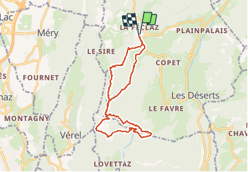
16,6 km | 24 km-effort
5h 15min
![](https://static1.geolcdn.com/siteimages/upload/files/16400158638029165_repeat_loop_refresh_sync_direction_icon.png)
Sí
![Excursión Senderismo Les Déserts - golet de l'agneau - Photo](https://media.geolcdn.com/t/375/260/ext.jpg?maxdim=2&url=https%3A%2F%2Fservices.sitytrail.com%2FGeolivesWS%2FDownloadMedia.ashx%3FTrailID%3D229605%26Media%3Dfix__20131028144817.jpg)
![Senderismo Senderismo](https://static1.geolcdn.com/sitytour/trail-icons/101.png)
golet de l'agneau
Senderismo
Medio
(1)
Les Déserts,
Auvergne-Rhône-Alpes,
Saboya,
France
![](/images/other/stat-length.png)
3,9 km | 10,2 km-effort
1h 44min
![](https://static1.geolcdn.com/siteimages/upload/files/16400158638029165_repeat_loop_refresh_sync_direction_icon.png)
No
![Excursión Senderismo Les Déserts - Circuit de la Croix Nivolet - Photo](https://media.geolcdn.com/t/375/260/ext.jpg?maxdim=2&url=https%3A%2F%2Fstatic1.geolcdn.com%2Fsiteimages%2Fupload%2Ffiles%2F1553511878bg_sport_marche.png)
![Senderismo Senderismo](https://static1.geolcdn.com/sitytour/trail-icons/101.png)
Circuit de la Croix Nivolet
Senderismo
Muy fácil
(1)
Les Déserts,
Auvergne-Rhône-Alpes,
Saboya,
France
![](/images/other/stat-length.png)
3,5 km | 5,6 km-effort
Desconocido
![](https://static1.geolcdn.com/siteimages/upload/files/16400158638029165_repeat_loop_refresh_sync_direction_icon.png)
Sí
![Excursión Senderismo Thoiry - le golet de l'agneau - Photo](https://media.geolcdn.com/t/375/260/95fcbe0f-c4e5-4eb2-ad04-6bb3c6835482.jpg&format=jpg&maxdim=2)
![Senderismo Senderismo](https://static1.geolcdn.com/sitytour/trail-icons/101.png)
le golet de l'agneau
Senderismo
Medio
Thoiry,
Auvergne-Rhône-Alpes,
Saboya,
France
![](/images/other/stat-length.png)
13,2 km | 26 km-effort
5h 20min
![](https://static1.geolcdn.com/siteimages/upload/files/16400158638029165_repeat_loop_refresh_sync_direction_icon.png)
Sí
![Excursión Senderismo Montcel - BAUGES: PETIT TOUR DE LA FORET DOMANIALE DU REVARD - Photo](https://media.geolcdn.com/t/375/260/ext.jpg?maxdim=2&url=https%3A%2F%2Fstatic1.geolcdn.com%2Fsiteimages%2Fupload%2Ffiles%2F1553511878bg_sport_marche.png)
![Senderismo Senderismo](https://static1.geolcdn.com/sitytour/trail-icons/101.png)
BAUGES: PETIT TOUR DE LA FORET DOMANIALE DU REVARD
Senderismo
Medio
(1)
Montcel,
Auvergne-Rhône-Alpes,
Saboya,
France
![](/images/other/stat-length.png)
12,4 km | 17,2 km-effort
3h 30min
![](https://static1.geolcdn.com/siteimages/upload/files/16400158638029165_repeat_loop_refresh_sync_direction_icon.png)
Sí
![Excursión Senderismo Mouxy - Sentier du Perthuiset - Photo](https://media.geolcdn.com/t/375/260/ext.jpg?maxdim=2&url=https%3A%2F%2Fstatic1.geolcdn.com%2Fsiteimages%2Fupload%2Ffiles%2F1553511878bg_sport_marche.png)
![Senderismo Senderismo](https://static1.geolcdn.com/sitytour/trail-icons/101.png)
Sentier du Perthuiset
Senderismo
Medio
(1)
Mouxy,
Auvergne-Rhône-Alpes,
Saboya,
France
![](/images/other/stat-length.png)
9,4 km | 19,9 km-effort
3h 19min
![](https://static1.geolcdn.com/siteimages/upload/files/16400158638029165_repeat_loop_refresh_sync_direction_icon.png)
Sí
![Excursión Senderismo Les Déserts - Revard : La Féclaz - Photo](https://media.geolcdn.com/t/375/260/ext.jpg?maxdim=2&url=https%3A%2F%2Fstatic1.geolcdn.com%2Fsiteimages%2Fupload%2Ffiles%2F1553511878bg_sport_marche.png)
![Senderismo Senderismo](https://static1.geolcdn.com/sitytour/trail-icons/101.png)
Revard : La Féclaz
Senderismo
Fácil
(1)
Les Déserts,
Auvergne-Rhône-Alpes,
Saboya,
France
![](/images/other/stat-length.png)
8,8 km | 10,6 km-effort
2h 22min
![](https://static1.geolcdn.com/siteimages/upload/files/16400158638029165_repeat_loop_refresh_sync_direction_icon.png)
Sí
![Excursión Senderismo Montcel - La Culaz - Photo](https://media.geolcdn.com/t/375/260/6c40c4b5-435c-4557-a5f4-da8b6d9d2eb0.jpg&format=jpg&maxdim=2)
![Senderismo Senderismo](https://static1.geolcdn.com/sitytour/trail-icons/101.png)
La Culaz
Senderismo
Muy difícil
Montcel,
Auvergne-Rhône-Alpes,
Saboya,
France
![](/images/other/stat-length.png)
15,7 km | 22 km-effort
6h 42min
![](https://static1.geolcdn.com/siteimages/upload/files/16400158638029165_repeat_loop_refresh_sync_direction_icon.png)
Sí
![Excursión Senderismo Montcel - La Croix du Berger - Photo](https://media.geolcdn.com/t/375/260/f986dc09-993f-4c5c-ae42-1f703662732a.jpg&format=jpg&maxdim=2)
![Senderismo Senderismo](https://static1.geolcdn.com/sitytour/trail-icons/101.png)
La Croix du Berger
Senderismo
Medio
Montcel,
Auvergne-Rhône-Alpes,
Saboya,
France
![](/images/other/stat-length.png)
8,8 km | 11,7 km-effort
2h 39min
![](https://static1.geolcdn.com/siteimages/upload/files/16400158638029165_repeat_loop_refresh_sync_direction_icon.png)
Sí